5 Collaborative Site Analysis Activity: Project Pizzademic & Renovating Satchel’s Amid COVID-19
Dr. Emily Bald
Course: Writing for Sustainability and the Built Environment (ENC 3459)
Description
 Students worked in teams to create a site analysis of Satchel’s Pizza in preparation for a hypothetical renovation project. Students this semester were not able to visit their project sites in person due to COVID-19. This in-class activity therefore gave students an opportunity to practice using online resources to explore and analyze a site in Gainesville virtually. It also introduced students in Sustainability and the Built Environment to a local restaurant off campus that shares their investment in sustainability. (Several students who had never heard of Satchel’s even ordered Satchel’s take-out the next weekend.)
After groups posted their site diagrams to the Canvas Discussion Board, we analyzed them as a class, discussing what the diagrams indicated regarding the possibilities and limitations of a renovation project.
Assignment Goals/Outcomes
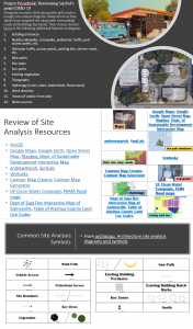
- Use online resources such as Google Earth, ArcGIS, and FEMA flood maps to explore and analyze a project site
- Assess and prioritize site conditions such as vehicular and pedestrian movement, topography, hydrology, and sun paths
- Create a site diagram (by hand) that presents site conditions clearly and accurately
- Practice the professional and generic conventions of site analysis, including common site feature symbols and legends
Assignment Setup (Instructor)
- Choose hypothetical renovation project site and purpose
- Compile lists of site analysis resources and common site diagram symbols
- Post instructions in a Canvas Discussion assignment
- Assign students to 3-4-person groups
Student Instructions
Your sustainable design firm has been contracted to renovate Satchel’s Pizza. The primary goal is to improve ventilation and create more outdoor seating space, making Satchel’s a more resilient restaurant in the midst of public health crises such as pandemics. The first step is analyzing the site to determine renovation possibilities and constraints.
In groups, create a rough site analysis diagram for Satchel’s. Designate an ‘artist’ of the group who will do the drawing/mapping. Advise them as they sketch the site along with surrounding roads and buildings (by hand). Then choose at least three of the following additional features to diagram:
- Building entrances
- Nearby sidewalks, crosswalks, pedestrian traffic, ped access points, etc.
- Vehicular traffic, access points, parking lots, service roads, etc.
- Bike paths
- Bus stops
- Sun paths
- Existing vegetation
- Topography
- Hydrology (rivers, lakes, watersheds, flood zones)
- Wind direction
- Views (of and/or from site)
- Noise sources
Remember to use the resources and common symbols provided below and include a legend to improve the clarity of your diagram.
Though one person is the illustrator, everyone in the group should pitch in with site research and advice. When you’re done, take a photo with your phone and post in the Discussion Board thread.
Grading (Instructor/TA)
This activity was worth 5 points (out of a total of 1000 points in the class). As long as the team’s diagram was complete and legible, it received full credit.
Tips and Suggestions for Instructors
This activity can be tailored to other disciplinary or professional contexts in which students need to explore a place virtually. The list of resources can be modified to encourage attention to different aspects of a place. For example, later in the semester, I created a very similar activity to teach social assessment of a site. Students explored the Duval Heights neighborhood using the ‘street view’ feature in Google Maps as well as searching GIS data, which helped them recognize a variety of health inequities in the area. Such activities can encourage students to expand their experience and understanding of Gainesville beyond the University and Midtown.
Keywords: COVID-19, group activity, virtual exploration, collaboration, teamwork, illustration
